Peterborough United reveal plans for new stadium as planning documents submitted


The club are pushing ahead with their plans to build a new stadium in the city and are committed to the fact that the Embankment is their preferred site; a decision that has caused controversy.
A number of campaigners are worried about the loss of green space and have set up the Save Peterborough Embankment Facebook page.
Advertisement
Hide AdAdvertisement
Hide AdIn July, Labour Group Leader on Peterborough City Council Shaz Nawaz wrote a letter in the Peterborough Telegraph in which he insisted that the labour group were against the plans, citing loss of green space as one of the reasons.
The club, however, insist that the development will enhance the public landscape and provide a range of events for the whole community, not just football fans.
Detailed plans about the development were revealed in an Environmental Impact Assessment (EIA) Screening Request, submitted to the council recently.
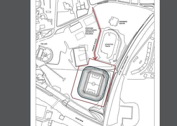
The document states that the proposed development would be up to 23.5m tall, with a floor area of circa 20,500sqm and would be located to the north of the of the existing athletics track, with the A1139 Frank Perkins Parkway running in a north to south direction to the east, the River Nene to the south and existing open green space to the west. The closest building would be the Lido and the Key Theatre to the west of the site.
Advertisement
Hide AdAdvertisement
Hide AdThis location has been chosen to “ensure that as much public open space is retained, and that the venue’s structure is set against the backdrop of made ground that supports the elevated section of the parkway further limiting space take.”
The initial capacity would be 19,400 with the possibility to expand that with the addition of safe-standing as well as two to three rows, giving the ground a final capacity of up to 24,000.
The club say that they envisage the proposed development providing the local community with a new state of the art venue for seasonal events, concerts, festivals, as well as corporate events alongside the football. The belief is that this multifunctional and flexible approach will attract new business, tourism, and investment, whilst also strengthening the already strong bond between Posh, the city and the community they represent.
In terms of infrastructure, there are plans for an “enhanced public landscape” through a new pathway to the west of the site (approx. 256m in length, 199m of public plaza with a 57m link). This is alongside extending the existing access road, on Bishop’s Road, which serves the athletics track, by around 390m, and this would then serve as an access road to both the new stadium and the new Anglia Ruskin university site, also planned for the embankment.
Advertisement
Hide AdAdvertisement
Hide AdIn order to mitigate the potential of extra traffic in the area, the club says that it will encourage fans and other visitors to the stadium to arrive via sustainable transport, plans to turn the existing Riverside Car Park, south of the Magistrate’s Court, into a multi-storey car park are being explored.
The roof will include a rain water harvesting system and the whole stadium will “aspire to deliver against an ambitious but achievable environmental agenda which would focus on delivering a venue that is a low C02 exemplar that deploys green technologies and renewable energy to reduce CO2 emissions and ensure sustainable development.”
The club also say that other potential uses of the site include a small number of offices, a sports bar/cafe, a media centre to be operational on match days (1000sqm), club shop and ticket office.
The document has been produced by the club to assess the impacts they believe the construction and the future development, once completed, will have on the area and have submitted the benefits and mitigations in support of their case.
There are still several stages of public scrutiny and reports the plans will need to be subjected to before gaining approval.
To view the document in full, visit the council’s planning portal.