When strongest winds are due as Met Office yellow warning remains in place for Peterborough
and live on Freeview channel 276
Friday saw widespread road and rail disruption, power cuts and a number of trees downed in the Peterborough area as Storm Eunice battered the region.
Storm Franklin has blown in hard on the heels of Eunice bringing more stong winds.
Advertisement
Hide AdAdvertisement
Hide AdThe Met Office is forecasting winds over 50mph in Peterborough today.

Hour by hour this is when they are due:
6am: Cloudy - gusts over 51mph
7am: Cloudy - gusts over 50mph
8am: Cloudy - gusts over 51mph
9am: Cloudy - gusts over 52mph
10am: Sunny spells - gusts over 51mph
11am: Sunny spells - gusts over 50mph
12pm: Sunny spells - gusts over 47mph
1pm: Cloudy - gusts over 44mph
2pm: Sunny spells - gusts over 40mph
3pm: Sunny spells - gusts over 37mph
4pm: Sunny spells - gusts over 34mph
5pm: Sunny spells - gusts over 33mph
6pm: Cloudy - gusts over 31 mph
7pm: Cloudy - gusts over 29 mph
8pm: Cloudy - gusts over 26 mph
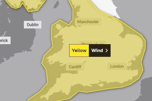
A yellow Met Office strong winds warning suggests; ‘some damage to buildings, such as tiles blown from roofs, could happen, along with trees/branches being brought down. Road, rail, air and ferry services may be affected, with longer journey times and cancellations possible. Some roads and bridges may close warning.’
The Met Office also issued an amber warning for wind which could cause “travel delays, road and rail closures, power cuts and the potential risk to life and property” in Northern Ireland from midnight until 7am on Monday.
Meteorologist Becky Mitchell said this is the first time the national forecaster has recorded three major storms in such quick succession since the naming system was introduced seven years ago.
Advertisement
Hide AdAdvertisement
Hide AdShe told the PA news agency: “This is the first time we have had three named storms within a week, and we started the storm naming system in 2015.
“At the moment we’ve got a really active jet stream, which is why we’re seeing so many storms track right towards the UK.
“We had Dudley on Wednesday, Eunice on Friday and Franklin today.”
Milder yellow warnings for wind also covered Wales, Northern Ireland and most of England from midday on Sunday until 1pm on Monday.
Advertisement
Hide AdAdvertisement
Hide AdEnvironment agencies have also issued hundreds of alerts for flooding across the UK.
This comes just two days after Storm Eunice caused what providers believe was a record national outage over a 24-hour period on Friday, with around 1.4 million homes affected.
The Environment Agency has issued 44 flood warnings where “flooding is likely” for locations mainly in the north and west of England, and 117 alerts where “flooding is possible” for the north-western half of the UK, London and the south coast.