Interactive flooding signs in Whittlesey could be on their way
and live on Freeview channel 276
A funding bid is being made to the Cambridgeshire and Peterborough Combined Authority for the signs which would indicate when the B1040 is closed and could also be used to communicate other information to passing drivers.
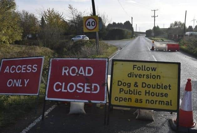
Currently, motorists are left frustrated when North Bank and the B1040 between Peterborough and Whittlesey are closed due to the River Nene flooding.
Advertisement
Hide AdAdvertisement
Hide AdMoreover, there is additional traffic disruption due to works to build a bridge over King’s Dyke Level Crossing.

The funding bid of £56,500 is due to be sent to the Cambridgeshire and Peterborough Combined Authority - the county’s mayoral body - for approval ahead of its meeting on November 30.
If the money is agreed it would be supplemented by £8,000 from Whittlesey Town Council and £500 from the Fenland District Council Leaders Fund.
Cllr Chris Boden, leader of Fenland District Council and a member of Cambridgeshire County Council, Whittlesey Town Council and the combined authority, previously spoke about the possibility of interactive signs with the Peterborough Telegraph.
Advertisement
Hide AdAdvertisement
Hide AdHe said if a funding bid from the town and district councils was successful one of the signs would be at the roundabout by Kellyvision in Whittlesey.
He added that an investigation had been carried out by an outside authority to see if North Bank could be raised to prevent the need for the road to be closed after heavy rainfall.
However, it was quickly established that this would cost millions of pounds.
The application for the interactive signals is part of the Growing Fenland project which saw masterplans drawn up for Chatteris, March, Whittlesey and Wisbech.
The Whittlesey plan included:
Advertisement
Hide AdAdvertisement
Hide Ad. Considering re-locating the Friday market to the pedestrianised area of High Causeway to “increase footfall” before turning Market Place into a “piazza” with outdoor dining. The plan includes attracting more specialist markets, such as antiques fairs, farmers’ markets and fine food markets, possibly on Saturdays, while offering customers incentives to keep visiting and reaching out to local businesses to take part
. Developing an “annual programme of locally sourced events, including themed evenings and weekends” in the square order to add “vibrancy”
. Creating a heritage visitor centre to showcase the remarkable Bronze Age discoveries at nearby Must Farm, as well as the story of Whittlesey from its beginnings to the current day. A site directly adjacent to King’s Dyke Nature Reserve has been earmarked as a potential location
. Creating a new heritage walk which would include historic landmarks in the town
Advertisement
Hide AdAdvertisement
Hide Ad. Identifying work placements/apprenticeship opportunities at local businesses and opportunities to re-train and up-skill adult workers.
. Bus franchising to introduce more - and more regular - services both in and out of the town and to and from the station
. More train services throughout the day and later in the evening
. A new park and ride scheme from the town centre to Peterborough
Advertisement
Hide AdAdvertisement
Hide Ad. Pushing ahead with the bridge over the rail line at King’s Dyke
. A new relief road from Coates to the Morrisons/Cardea Roundabout in Peterborough so that Heavy Goods Vehicles (HGVs) can access industrial sites from the east rather adding to the congestion of residential routes.