Motorists face flooded roads in Peterborough as more rain is forecast


There is a flood warning in force near Peterborough with concerns about the North Bank Road alongside the River Nene west of Dog-in-a-Doublet Sluice.
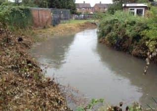
The Environment Agency also issued a flood warning for Peterborough Brooks. A statement said: “Heavy rain falling in the River Welland catchment is expected to continue throughout Sunday July 28. This is causing Paston Brook to rise.
Advertisement
Hide AdAdvertisement
Hide Ad“The rising river levels have already caused flooding of low lying land and roads in the north part of Peterborough, and we now expect properties to be affected. Low lying properties near to Paston Brook, Werrington Brook, Marholme Brook and Brook Drain are most at risk.
“Remain safe and be aware of your local surroundings. Please avoid contact with flood water. Our staff are out in the area to check the flood defences, clear blockages, and assist the emergency services and council. We will be closely monitoring the situation and this message will be updated as the situation changes.”
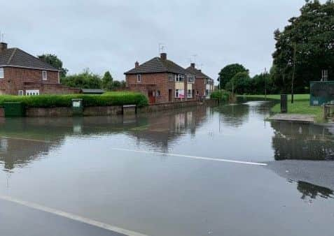
Peterborough Telegraph readers have contacted us to say roads in several parts of the city have flooded.
Hayden Shepherd said Corfe Avenue and surrounding roads are flooded, including Rockingham Grove.
Advertisement
Hide AdAdvertisement
Hide AdAnna Nyczka said water levels in the brook off Fulbridge Road were very high and others told us rodas in Walton were under several inches of water
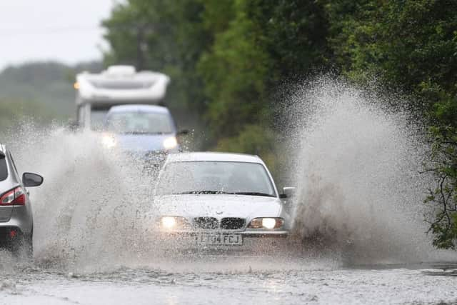
The Environment Agency said heavy rain over the past week has caused river levels to rise on the River Nene.More heavy downpours could signal further disruption for travellers as the changeable weather continues.
The Met Office has issued a yellow weather warning for rain across parts of the Midlands, including Peterborough, the North West of England, Northern Ireland and south-west Scotland until midnight on Sunday. Peterborough is due to see more heavy rain between 7pm and midnight toninght (July 28).
Forecasters say the heavy rainfall could bring flooding and road closures, as well as potential delays to bus and rail services.
Advertisement
Hide AdAdvertisement
Hide AdIt comes after a week in which Britain was hit by hot temperatures and thunderstorms, with the heatwave causing problems for train and air passengers.
Meteorologist Mark Wilson said the next few days would bring a “mixed bag” of weather, but temperatures would be markedly down on Thursday’s record-breaking highs.
He said: “The parts of the country covered by the weather warning (on Sunday) can expect to see some heavy rain. There is the potential for disruption with difficult driving conditions and it could affect things like buses or trains.
“The best of the weather on Sunday will be across south-west areas, where it will be fairly dry with sunny spells and highs of 23 or 24C.”
Advertisement
Hide AdAdvertisement
Hide AdOvernight on Saturday into Sunday, parts of Scotland saw approximately 40mm of rain, while Cumbria and the North West of England were also hit by downpours.
The potential for disruption comes amid repair work affecting the London St Pancras-Nottingham-Sheffield rail route this weekend.
East Midlands Trains (EMT) customers were told to check before heading out on their journeys and not to travel on the route due to a reduced timetable.
Meanwhile, passengers using Heathrow and Gatwick airports have had to contend with delays due to the extreme weather conditions across Europe.
Advertisement
Hide AdAdvertisement
Hide AdThis morning (Sunday, July 28), Gatwick Airport said: “We aim to run a normal schedule today, however due to ongoing adverse weather across Europe, passengers are advised to check with their airlines for the latest information.”
Heading into next week, heavy showers and thunderstorms could return to parts of the UK on Monday and into Tuesday, while temperatures are likely to be back to normal for the time of year.
Email your Peterborough flood pictures to: [email protected]