
Met Offices issues thunderstorm warning for Peterborough TODAY after record-breaking May temperatures
The thunderstorms could bring 30mm of rain in less than an hour
The Met Office has issued a thunderstorm warning for Peterborough today (Tuesday, May 26) after record-breaking temperatures over the late-May bank holiday weekend.
Temperatures in the city soared past 30C yesterday (Monday, May 25) in what was a record-breaking day for the UK.
A weather station at London’s Kew Gardens recorded 34.8C, making it the hottest May day on record.


Peterborough is once again in for a scorching day, with temperatures expected to hit 32C this afternoon.
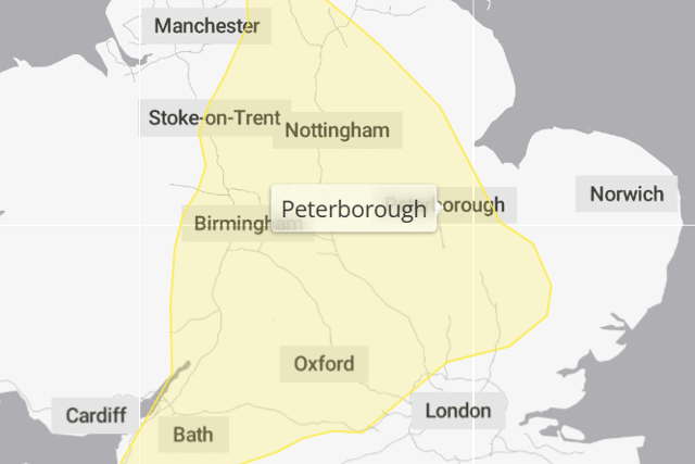
But the Mediterranean-like weather could be interrupted by thunderstorms, with the Met Office issuing a yellow warning for central England.
The warning, in place between 3pm and 10pm today, says: “Whilst many areas will miss them and remain hot and sunny, isolated thunderstorms are possible this afternoon and into the evening.
“These could bring frequent lightning, large hail, gusty winds and the potential for 30 mm of rain in less than an hour.”
When will the heatwave end?
With Peterborough having recorded three consecutive days of 28C or higher, the city experienced an official heatwave over the bank holiday weekend.
While temperatures are expected to fall slightly tomorrow (Wednesday, May 27), they will begin to rise again as the week goes on.
By Friday, Peterborough is once again expected to enjoy highs of 25C as warm air continues to rise from the south.
Tuesday, May 26
Highs of 32C and lows of 13C. Sunny and light winds.
Wednesday, May 27
Highs of 23C and lows of 10C. Sunny intervals and a gentle breeze.
Thursday, May 28
Highs of 26C and lows of 15C. Sunny intervals and a gentle breeze.
Friday, May 29
Highs of 25C and lows of 12C. Sunny intervals and a gentle breeze.
Saturday, May 30
Highs of 25C and lows of 13C. Light rain showers and light winds.
Sunday, May 31
Highs of 22C and lows of 14C. Light rain showers and a moderate breeze.