He starts with the former County Court of 1873 on Laxton Square - Cattle Market Road corner.
It is of red and yellow Victorian bricks, he says, with stone detailing and skilfully includes architecture that mirrors that of the nearby Peterborough Cathedral i.e. round arches, blind arcading, corbel machicolations and even a rose window.
The image is from November 1988 and shows the extension and restoration of the building to become a nightclub – 5th Avenue and Central Park.
I went to the bar a number of times but my nightclub days were over, my venues having been the Home Club, the Spinning Wheel, Cloud Nine, Anabel's, the Flamingo and La Scala.
A low brick wall surrounded the building and the owners squeezed metal tables and chairs behind it for open air coffee and snacks. On a Saturday we would often have a triangle of Pizza and coffee and watch the world go by.
The building has been abandoned for many years and has suffered greatly from Peterborough's pigeon population. In recent years a new hoarding appeared and some work started. Signs advertised 'Fifth Avenue - Peterborough's First Co-living Concept' but work stopped and the building remains in a very sad condition and I am afraid in the light of new development in the area an eye-saw.
Perhaps in the future it will retrieve its former glory.
NORTHMINSTER
Two photographs of Northminster looking west which actually can be fixed together to make a panoramic image, taken in December 1988.
Northminster was formed sometime in the late 1960s to early 1970s. It follows the line and is built on the old cattle market and covers over where the metal railed cattle pens, the auction building and small animal cages once stood.
On the 1988 photograph can be seen the edge of the multi-storey car park which was made by using an experimental system which involved pouring the floor slabs on the ground and jacking them up and pinning them to pre-formed concrete columns. This form of construction was later was found to be suspect and the building was demolished in 2020. In the background (L to R) we can see: The Embassy, with the stage door-loading dock still visible; The College (yet to be the College Alms); the old Library; and St Peter and All Souls Catholic Church, Park Road. The one storied blue and yellow building were once the showrooms of Emway Motors which specialised in three wheeled cars.
Looking at the second photograph. On the left is the construction, in progress, of the new Peterborough Central Library on Broadway. The light-coloured building in front of the tower crane, on the corner of the passage to Stanley Recreation Ground (now upgraded to a Park), was originally Martins Bank and has had many reincarnations since, usually food outlets, its latest being 'AY Food'.
The 1988 image shows it to be made of light buff-coloured bricks but now the facade is a deep red. Further investigation reveals that at some point the brickwork has been skilfully colourised. On the right we can see the redeveloped Northminster House which currently has offices to rent.
CITY ROAD south
City Road looking towards St John's Street (taken July 1983). The then new Passport Office (possibly originally offices for a bank) is on the left with the construction of Stuart House in the background. On the right is building works in progress for 'Monkstone House: 1984' which for many years housed Greenwoods the solicitors. In the background is Tout Hill which was offices occupied by 'The Peterborough Development Corporation'. This was named after a mound in the Cathedral grounds (the former Dean's gardens) which was commissioned by William the Conqueror in 1073 as a defensive structure. It is sometimes referred to as Mount Thorold or Peterborough Castle. In the distance can be seen St Mary's flats before they received their recent externally insulated cladding.
CITY ROAD north
These views are of City Road showing the construction of Stuart House (April 1984) and how it looks now. In recent years the entrance corner has been faced with smooth painted panels. The brick plateau at the front of the building once housed at least one of the Gormley Statues before its departure to Ferry Meadows and eventually to its current home on one of the roofs of the city centre. Also, there was a piece of art made of rusty steel sheets which may be the untitled sculpture which currently stands outside the Key Theatre. In the background on the 1984 photograph can be seen the pub formally known as the Clay Pipe (later Good Barns Yard P.H. and now the Ishtar Turkish Grill).
COWGATE
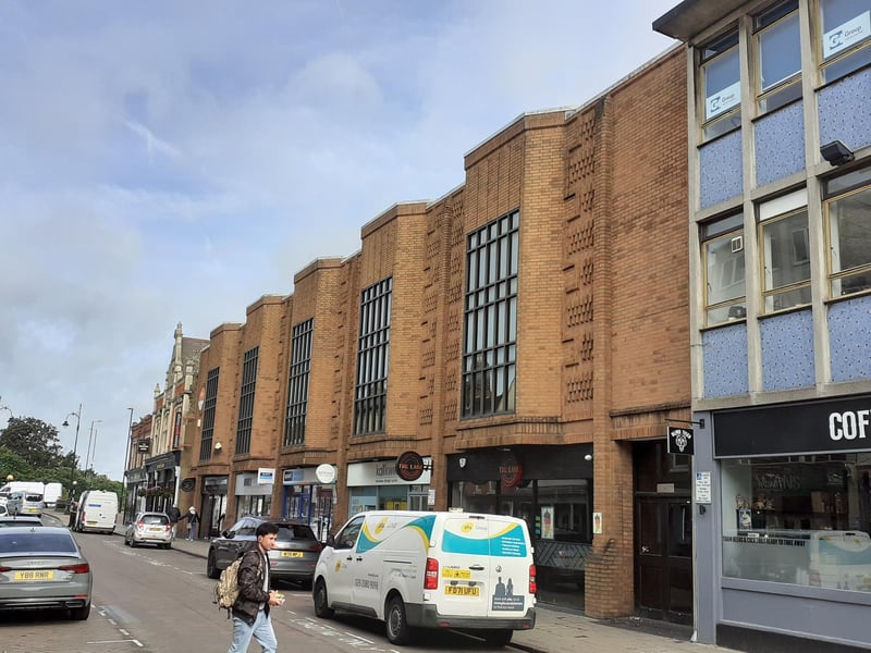
The North side of Cowgate in my photograph from September 1982 entitled: 'Site of new Snooker Hall'
In the back ground you can see the gable of what is now Wetherspoon’s Drapers Arms. I assume in 1982 this was still Armstong's Drapers Shop or possibly the very early days of the Old Monk pub.
The ground floor businesses now are (Left to right): Heavenly Desserts, extra staff, quest employment, kallkwik business design + print and The Ladz restaurant.
ST JOHNS STREET
I took this photo – New Offices St John's Street – in December 1983 and it is now Stuart House (northern section). St Mary's Church is still visible prior to demolition in 1989.
NEW ROAD
Early 1980s. Construction of Stuart House on the right. St Mary's Flats with their original brickwork prior to the addition of external insulation (twice) in recent years.
RIVERGATE
In the summer of 1988 the Rivergate Centre was being constructed. The reinforced concrete outfalls of a former power station are the nine openings to the left. From that point the river bank stepped back and there was no footpath heading towards the town bridge. After Rivergate and the Riverside flats were completed a wall of steel interlocking sheet piles was driven into the river bed level with the outfall to form a retaining wall. The up-to-date photo shows the much-talked about sinkhole.
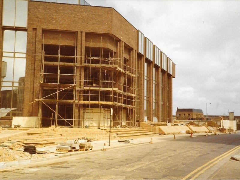
9. City Road
1984 - City Road north and the construction of Stuart House - with the Clay Pipe pub in the background Photo: Andrew Cole
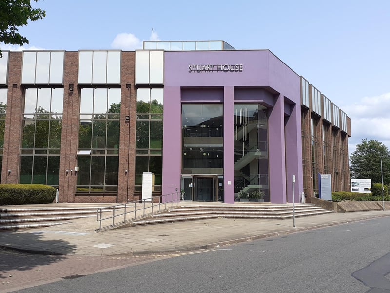
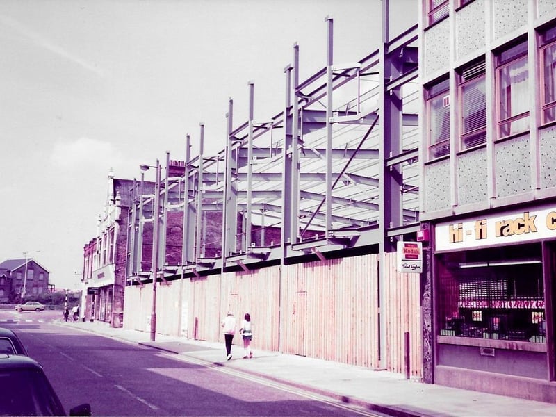
11. Cowgate
September 1982 in Cowgate - with the snooker hall under construction Photo: Andrew Cole