Plans for new cycle path between Sutton and Nene Valley Railway opposed over safety concerns
and live on Freeview channel 276
The Peterborough Telegraph revealed that plans for a new cycle and footpath had been submitted to Peterborough City Council following the efforts of volunteers from the Peterborough Cycle West Project and sustainable transport charity Sustrans.
The plans have received the backing of Nene Valley Railway and Nene Park Trust, with the latter believing that the new route would increase access to its land.
Advertisement
Hide AdAdvertisement
Hide AdHowever, Sutton Parish Council has claimed that the application “does not consider limited infrastructure and existing road use demands”.

It added: “Cyclists are an important user group and the residents of Sutton fully support the Nene Park masterplan, however, they feel that the current plans around Sutton do not consider the safety of pedestrians who make up the largest group of local users.
“The proposed cycle route by Peterborough Cycle West (PCW) aims to open up access to the village, but parish councillors from Sutton and Stibbington, and local residents, are concerned for the increased number of visitors - both cycling and in vehicles - this would attract to the village which does not have any footpaths, very limited parking and narrow single-track sections on the Quiet Lane status road.”
Mick Grange, Sutton parish councillor, added: “Sutton is an extremely small cul-de-sac village with a road infrastructure unsuitable for its existing needs, let alone more cycling and motorised traffic which will undoubtedly be drawn in with the PCW plans.
Advertisement
Hide AdAdvertisement
Hide Ad“Many of the properties have blind drives, some with mirrors to aid safe exit onto the road. Pedestrian gates which direct onto the road are also a real hazard.
“We already experience issues between road users and noticed a marked increase during lockdown with more visitors to the village. We are extremely concerned for the safety of our villagers and visitors alike whether they are walkers, cyclists or horse riders.
“Part of the PCW route is a high-risk flood area and the rail line is identified as part of a habitat enhancement zone by DEFRA (the Department for Environment, Food and Rural Affairs). It is home to a number of protected species and making such drastic alterations to the landscape could have a significant adverse effect on these.”
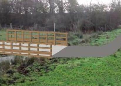
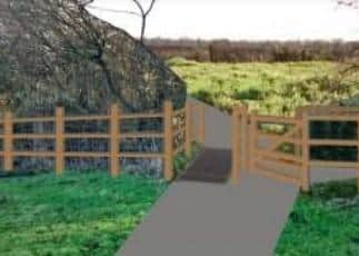
Under the plans submitted to the council, the shared-use path would be a 2.5m wide tarmac surface at ground level and would utilise part of the safeguarded land of the former Wansford to Stamford railway line.
Advertisement
Hide AdAdvertisement
Hide AdThe path would then cross an existing field ditch onto a new 3m wide timber cycle/footbridge before continuing under the eastern most flood span of the railway bridge.
A new, wider flight of steps would then replace the existing narrow and steep steps leading up to the footbridge across the River Nene to the NVR station.
These would also have a landing at the midpoint and top to allow users to see across the footbridge and any oncoming people.
A ‘wheeling rail’ is proposed on the steps to make it possible for cyclists to push their bicycles up to the bridge, while a cycle rack for a limited number of cycles would be provided at the bottom of the steps for those who wish to leave their cycles there and walk across to the NVR.
Advertisement
Hide AdAdvertisement
Hide AdAt present, the footbridge is a permissive right of way, owned by NVR.
The parish council said a survey showed that 72 per cent of residents are against the application but are in favour of a safer route for cyclists, walkers and horses in keeping with the character of the village.
It added: “The parish council and local residents have been working hard with Highways England to create a new route for cyclists, walkers and horse riders as part of the A47 dualling between Sutton and Wansford.
“This existing, funded scheme will open up huge opportunities for all leisure users and non-motorised commuters in the area, to and from Peterborough and locations in the west like Wansford, Stibbington, Oundle, Tansor, Elton, Yarwell, Nassington, Kings Cliffe and more.
Advertisement
Hide AdAdvertisement
Hide Ad“Highways England have confirmed that they are continuing to work with Peterborough City Council officers and local parish councils to ensure both the new dual carriageway and non-motorised users are provided safe, value for money transport means in the area.
“The proposed routes within the A47 Dualling project take all safety, ecological and heritage concerns into consideration and a formal announcement is due to be released In October.”
The planning application can be viewed on the Peterborough City Council website.
Comment Guidelines
National World encourages reader discussion on our stories. User feedback, insights and back-and-forth exchanges add a rich layer of context to reporting. Please review our Community Guidelines before commenting.